ASO keywords
Most repeated terms in the listing. Highlighted ones also appear in the title.
kruger9turn6park5road5turn turn5kruger nav5map4wildlife4live4gate4places4routing engine3turn navigation3camp gate3wild card3live location3signal3nav3offline3roads3card3export3national2data2
What's new in 6.4
NEW
- Offline Field Guide – around 3,000 Wikipedia articles on Kruger's wildlife, plants and places, readable with no signal. They appear in search below the Species Database.
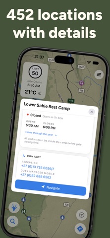
- Gate times – entrance gate and camp gate opening and closing times on every gate and camp, with a live open/closed status and countdown.
- Gate guides – what to expect at each entrance gate: the paperwork you need, conservation fees and the Wild Card.
- Camp history – the stories behind most of Kruger's camps.
- Richer place cards – new Facilities and Contact sections with tap-to-call numbers, website, bookings and email.
- Create your own KML files – a step-by-step wizard with custom fields.
- Use KML lines as roads – add your own tracks to the road network and navigate along them.
- Paper map finish – an optional paper grain and vignette (Map Design → Paper).
- Overlay chips – tap to quickly switch off Animal Density, Rainfall or River Catchments.
IMPROVED
- Navigation: an arrival tone and "You've arrived" message, fewer false arrivals, and stops you drive past are now marked as visited.
- Road number signs stay visible during navigation, and more appear as you zoom in.
- The moon card now shows a more detailed moon for each day.
Released Aug 13, 2026. Current version shipped Oct 8, 2026.
Store description
Navigate Kruger National Park with turn-by-turn directions that work anywhere in the park — even with no signal, no data and no roaming. The entire map is already on your phone.
Kruger Nav is an offline-first safari companion, built for one park and nothing else. The map, the routing engine, the wildlife guide and everything you save all live on your device — so the app works exactly the same at a remote waterhole as it does at the gate.
BUILT FOR THE BUSH
Offline turn-by-turn navigation. A custom routing engine plots your drive on the device, with no signal required. It keeps every route inside the park, prefers tar over gravel for a smoother ride, and warns you about closed and restricted roads.
The most detailed Kruger map you'll find. Every road, river, camp, gate, picnic spot and waterhole, drawn in fine detail — with optional terrain hillshade so you can read the hills and valleys.
A wildlife field guide to 240+ animals. Mammals, birds, reptiles and more, each with the best time to spot it, how rare it is in Kruger, plus diet, habitat, behaviour, conservation status and names in five languages.
An offline encyclopedia. Around 3,000 Wikipedia articles on Kruger's wildlife, plants and places, readable with no signal.
See the best roads for sightings. Shade the road network by animal density and head where the wildlife actually is.
Plan the perfect drive. Start from a curated half- or full-day route, or build your own with multiple stops and a realistic bush ETA at your chosen speed.
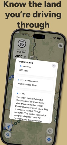
Read the landscape. Overlay rainfall, river catchments, flora and geology, and tap any zone to learn what you're driving through.
AND EVERYTHING ELSE
- Drop sighting pins and link them to a species
- Unified search across places, animals, articles and raw coordinates (DD, DMS, DMM)
- Sunrise, sunset, moon phase and a multi-day forecast
- Entrance and camp gate opening and closing times, month by month, with a live open/closed status
- What to expect at each entrance gate: paperwork, conservation fees and the Wild Card
- The history of Kruger's camps
- Import, create and export KML/KMZ to share routes and places with your group — and use your own tracks as navigable roads
- The full SA National Tree List — 1,625 trees, searchable by NTN sign number
- Store your SANParks Wild Card details and export a tidy PDF card
- Illustrated guides to animal spotting, sighting etiquette and Kruger's history
- Over-the-air road and closure updates, with no app update needed
- Switch the whole app between kilometres/°C and miles/°F
PRIVATE BY DESIGN
No account. No login. No tracking. No ads. Your saved places and sightings never leave your phone unless you export them. The only things the app ever fetches are updated road data and the weather.
Kruger Nav is an independent app, made by people who'd rather be watching the road for lions. It is not affiliated with or endorsed by SANParks.
Download Kruger Nav and take the whole park with you.
Note: live location and turn-by-turn navigation require GPS. Every iPhone has GPS; on iPad, only cellular (SIM/eSIM) models do — a Wi-Fi-only iPad can view the map but can't show your live location.
See this store page in another country
Prices, ranks and reviews are per country. Revenue above is already worldwide.