ASO keywords
Most repeated terms in the listing. Highlighted ones also appear in the title.
gold9maps8old7detector6ground5detector maps5relics4relic4gps4coin4hunting4offline4finds4usa4zealand canada3historical maps3coin shooting3coin relic3relic hunting3old workings3offline maps3monthly usd3built3australia3
What's new in 6.0.1
NEW FOR THE USA
• Gold states: new map styles, detailed state geology with a gold host rock filter, and Alaska.
• Land Permissions (coin & relic): keep the properties you have permission on, with landowner details, access notes, rules and photos of your agreement. Mark each field's state and share a permission as a pack.
• Dynamic LiDAR replaces the old hillshades. Change its colours, brightness and contrast, and save your favorite looks.
• Terrain+: build a 3D model of the ground from USGS lidar. Its tools highlight possible old workings, natural gold traps and where gold may have shed downhill.
• Property boundaries now show from zoom 13.
• A Roads switch on the Washington map.
Released Sep 22, 2025. Current version shipped Oct 12, 2026.
Store description
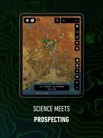
Detector Maps is the field tool that keeps you on the gold - and on the relics. Built by geologists for prospectors, relic hunters and metal detectorists across the United States, Australia, New Zealand and Canada, it pairs geological data and historical maps with rock-solid GPS so you spend your time on high-potential ground, not guessing.
Whether you are swinging a detector for gold nuggets, coin shooting an old homestead, hunting Civil War relics or panning a creek, it puts serious research intelligence in your pocket - and it works offline, where the finds actually are.
COIN & RELIC HUNTING - NATIONWIDE
Research old towns, ghost towns, homesteads, schoolhouses and long-forgotten gathering places - the ground where old coins, buttons, buckles and relics are still waiting.
- Historical map overlays: hunt the buildings, roads and fields the modern map forgot
- Historic USGS Topo maps, coast to coast
- LiDAR that reveals cellar holes, old roads and house sites hiding under the trees
- Plan permissions with confidence before you knock
GOLD PROSPECTING - 15 STATES
Serious geology for nugget hunting, from California to the Carolinas. Detect where gold has already been found, then find what the old-timers missed.
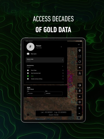
- Historic gold mines, diggings and workings - proven gold ground
- Surface geochemistry with pathfinder-element filtering
- Current and expired mining claims, updated every weekday
- 1-metre LiDAR hillshade that reveals old workings worth a closer swing
DETECTOR ACADEMY
A built-in crash course: 34 short video lessons, most under a minute - layers, LiDAR, waypoints, trails, offline maps and Pro tools.
DETECTOR GRIDS
Plan complete, methodical coverage of a site with adjustable search lanes you follow while recording your trail - never grid the same ground twice.
BREADCRUMB TRAIL TRACKING (BACKGROUND GPS)
Record your exact trail even with the app in the background or the screen off. See where you have walked and save paths for the next trip.
WHY WE REQUEST "ALLOW ALL THE TIME" LOCATION ACCESS
Detector Maps only uses background location when you switch breadcrumb tracking ON, keeping an unbroken log while your phone is idle. Disable it anytime in the app or device settings.
WAYPOINT MARKING AND FIND LOGGING
Drop waypoints on coins, relics, gold finds and old workings. Add names, notes and photos, then sync securely between your phone and the web app so your finds are never lost.
REAL-TIME GPS NAVIGATION
Watch boundaries, geology, historical maps and terrain update around you as you move - a GPS built for prospecting, coin shooting and relic hunting.
COVERAGE
USA COIN & RELIC: Nationwide
USA GOLD: CA, AL, NC, AZ, NV, ID, OR, UT, CO, MT, WA, SC, VA, GA, NM
AUSTRALIA: QLD, NSW, VIC, WA, SA, TAS, NT
NEW ZEALAND: historic goldfields, geology and offline maps
CANADA: British Columbia
SUBSCRIPTION INFORMATION
All plans include every map, standard data layers, offline downloads, and access to Australia, USA, New Zealand, Canada (BC) and the UK.
USA Pricing - Explorer Monthly: $7.99 USD; Explorer Yearly: $59.99; Pro Monthly: $11.99 USD; Pro Yearly: $99.99 USD.
Payment is charged to your Apple ID account at confirmation of purchase. Subscriptions renew automatically unless cancelled at least 24 hours before the end of the current period. Manage or cancel anytime in your App Store account settings. Pricing may vary by region.
PRIVACY AND DATA
Your location, trails and waypoints are used only for core app functionality. Delete your account anytime: Profile > Delete Account > type "confirm" > tap Delete.
Privacy Policy: https://app.detectormaps.com/privacy-policy
Terms of Use (EULA): https://app.detectormaps.com/license-agreement
Whether you swing a GPX 6000, an Equinox, a Manticore, a Deus or a Gold Monster - or a sluice or a pan - Detector Maps helps you cover more ground, log your best finds, and read productive terrain like a professional.
See this store page in another country
Prices, ranks and reviews are per country. Revenue above is already worldwide.